Sunday, October 14, 2012

Shrine Pass Trail - Best wildflowers viewing spot in Colorado


Update on 8/3/2014
I went on this trail again and now I really understand why this trail is called "best flower viewing area". The flowers are all over the hills and by the trail. You can see yellow, purple, orange, pink, red, white, blue different colors. It is just amazing and breath-taking! 

Aug 19th 2012 - Shrine Pass
This trial is a little bit far away from Denver Metro. Exit 190 on I70 W then turn left to Shrine Pass Road follow for other couple miles dirt road to get to the trail head.
There are facilities at the trail head and the parking lot is relatively small for the peak season. So we were surprise when seeing a few parking spot available at around 10am.
This hike is about 5 miles round trip and family friendly. A great meadow view appeared right after passing the bushes at the beginning of the trail. The bliss was so great. On the way hiking up hill, there were a group of sheep can be seen in the distant to form a beautiful nature photo.    

I was so excited before going to this hike. I have seen somebody’s pictures taken at this area with the blooming wildflowers. So I was looking for the breath-taken flower fields but didn't even  see anything impressive. The hope to see the flower fields was broken when we finally got to  the summit. No flowers at all - What a disappointment! We figured the reason why the flowers were all gone earlier than other years is the drought Colorado has been suffering this Summer. 

Well, a wildflower hike turned out to be a no-flower-at-all hike. However, the view on the summit is still stunning. I will have to come back here next year! 


Sunday, August 12, 2012

Rocky Mountain National Park - Glacier Gorge Trail


Alberta Falls
Direction to the trail head from Denver: Take US 36 all the way to west. Be sure to make a left when you see a gift shop called Indian Village when you pass the main street in Estes Park. Follow the sign to RMNP to get to Meadow Beaver Entrance.   Make a left onto Bear Road and keep driving for a few miles until you see the sign of Glacier Gorge. Bear Road is currently under re-construction and is close between 9 – 4.  Many times, the park closes some trails or roads for varying reasons, It is better to call the park ahead of the time to make sure the trail you are going is open.

The total length of this trail is 4.5 miles with the destination at Sky Pond. There are many scenic stops along this trail so if you don’t want to go all way down, it is still a very nice hike. Our hike was delayed 30 minutes at 9:30am because the shuttle to the trailhead was too busy to carry everybody right before the closure of Bear Road. The trail was pretty busy between the trailhead and Alberta falls. 

Smokes from the wild fires in Fort Collins
We saw the heavy smoke caused by the wildfire in Fort Collins. I have heard about Produe Canyon where the wildfires are burning is the great mountain getaway. Hopefully the fire will be under the control soon.

 
 A stream coming down from the mountain along with the hiking trail creates a great view. Wildflowers grow very well by the stream. Two girls were having picnic on the big rock here. What a great engagement between the human being and the nature.

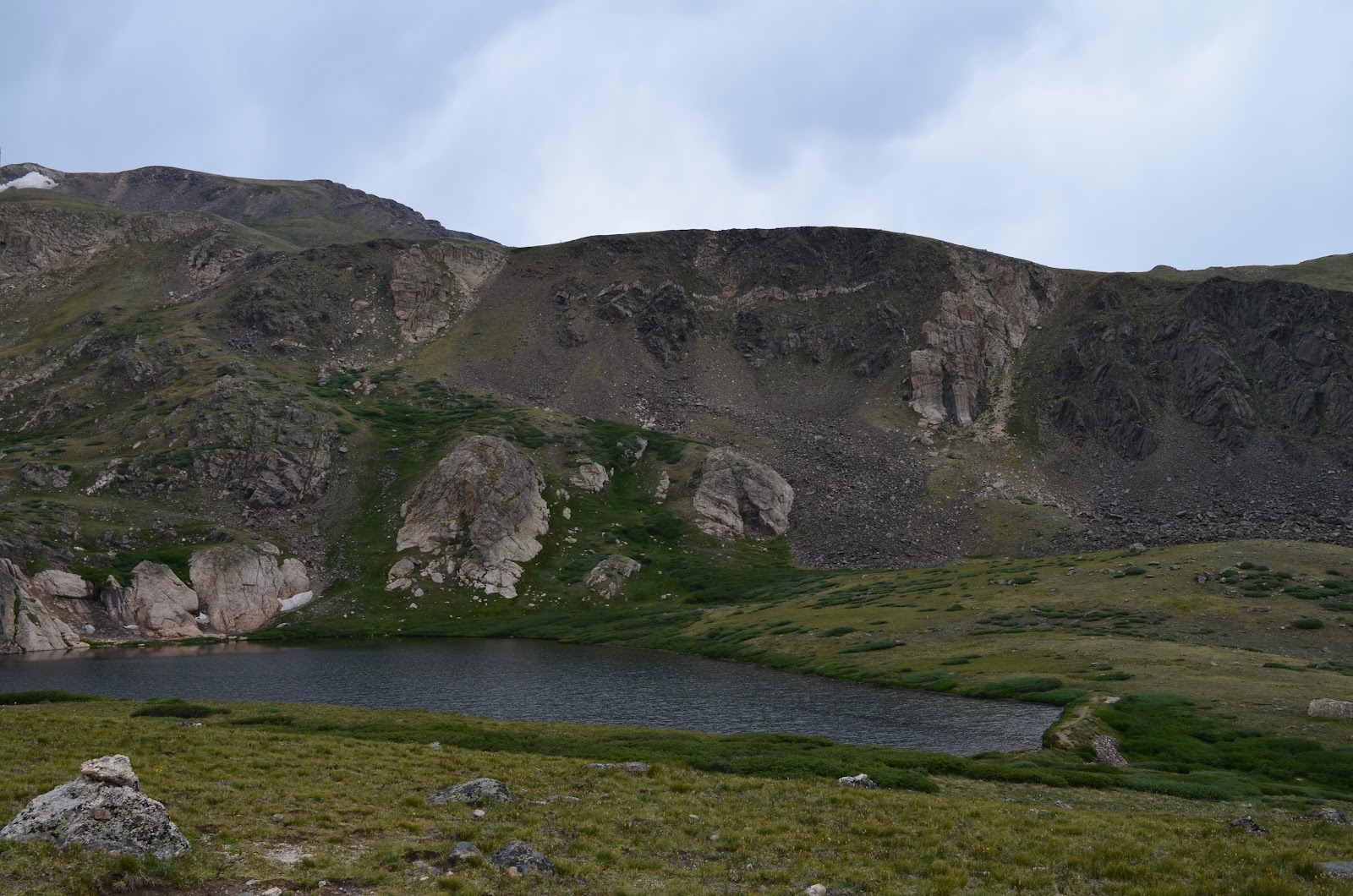
The next stop is called the Loch. It is a big lake with snowy mountains around it. Very windy by the lake so if you want to take a picture of yourself, be carefully not to lose your hat.
The loch
Everything here is nice except the giant mosquitoes. I didn't realize mosquitoes could survive in the mountains at above 9000 feet. It is highly recommended to bring a bugs spray with you.

After passing the loch, continue hiking for another 1 mile, you would get to Timberline falls. In order to get close to the falls, you will need to climb with your hand. It is not the most difficult part of this hike. From Timberline to Sky Pond is. I wasn't comfortable enough to give a try so I turned around after taking pictures and lunch break in front of the falls. The funny thing was a guy asked me to be his model so he could focus on me then quickly took my spot over for a self-portrait for himself. He said he would need this for his Facebook.  I guess, because of the facebook, people are becoming more creative and more aware of what are happening around them.  

Timberline Falls

Rocks to climb for Sky Pond
'I need a great Facebook picture!'


The way back wasn't pleasant as the way up because the sun was pretty strong and hot around the noon. On my way exit the park, I was told US36 to Estes Park was closed because of  new wildfire in Estes Park. I felt so sad about all these fires. This summer has been so dry and hot...please give us some rains!

I took US34 instead and sat in the traffic for about  30 minutes. Got home exhausted!  

Sunday, July 29, 2012

Coon Hill

7.1.2012 - Coon Hill South Ridge Route

To get to the trailhead from Denver, pass Eisenhower tunnel on I70 and park the car on the right by the tunnel. Climb up the hill on the left, you will see the trailhead. I don’t remember seeing any sign for this though. Details about this trail can be found here:  Coon Hill in SummitPost


Climbing up


This hike is only 2 miles round trip but with 1217 feet elevation gain. You pretty much keep climbing up all the way to the peak. Some parts of the hike could be very narrow and slippery with loose small rocks. A few people fell during the hike…please be very careful and watch on your steps. There is a few streams cross the trail, which makes the plants and wildflowers grow much better than other spots. We were hoping to see the blooms of wildflowers but not much luck. Though we did see a few usual big bunch of blue columbines on the way.  

Mountain views

wildflowers

Alpine forget-me-not

Last step to the peak


When you get to the peak, you know it worth all your efforts. As I said, the hike is short but steep, you need to bring plenty of water. Also, a common problem for high country hiking is no good spot for restroom.  There is no public restroom by the trail head or parking area either. We ended up driving down to Idaho springs exit for the restroom break. Even if there wasn’t a restroom need, you would still need to drive down there in order to turn around. It was about 1pm when we started heading back to I70 East…the traffic was already horrible and it took us about 1.5 hour to get back to 44th & Ward Rd PnR.  I have heard the traffic jam between Georgetown and the tunnel was the worst on Sunday after noon. It seems correct. 
Colorado State flower - Blue Columbine


Rocky Mountain National Park - Lily Lake & Bear Lake

7.7.2012 Rocky Mountain National Park

A friend in town this weekend so I took him to Rocky Mountain National Park. When we got to Meadow Beaver entrance, we were told Bear Road was close between 9-4 due to the construction. I totally forgot about that because the last hike I went in RMNP was before 9am. My friend wasn’t comfortable going to a long hike and plus it was raining, we decided to go to Mary’s Lake and Lily Lake. These two lakes are a few miles away from the Meadow Beaver entrance and can be reached by car.  The details can be found in Protails: Lily Lake & Bear Lake and in RMNP Bear Lake Road Trails

The water in Mary’s Lake is pretty low. Not sure whether it is because of the hot and dry summer this year. Water is clear enough to see the sand underneath. I was surprise to see somebody fishing in the rain, especially when he told me he had caught a few fish already. The lake in the rain looked misty and beautiful. Too bad there is a electricity tower built by the lake, which destroys the view.
Mary's Lake

Lily lake is right cross to Twins Lake Trailhead. In the lake, a group of ducks happily swimming and the beavers sneaking around the dead trees in the lake. The rain wasn’t too bad but the trail around the lake was pretty watery. 
Ducks in Lily Lake

Lily Lake

After hiking around the lakes, it was about 4pm so we went back to RMNP fee zone and drove up to Bear Lake trailhead. Bear Lake is only 250 feet from the parking lot. It is most popular spot in RMNP because of the accessibility. The parking lot is always full during the peak hours so many people park their cars in PnR and take the shuttle from moraine park, Glacier Gorge or Bierstatd Lake. The shuttle bus is pretty convenient and runs about every 15 minutes.  I have been to Bear Lake a few times so this time, we didn’t stay long here. Instead, we headed down to another trail that leads to Dream Lake. Dream lake is 1.1 miles from Bear Lake trailhead. There is another lake Nymph in between, which is 0.5 mile from Bear Lake. Nymph is a very quiet lake and covered with yellow pond lily.

Nymph Lake

Dream Lake

Pond Lily in Nymph Lake

A big mushroom

On the way to Dream Lake, chipmunks jumped around and hoped to receive food from the hikers. ‘Do not feed the wild animals’ is the rule but many people still do. Chipmunks do look cute when they have food but I rather to be safe. Dream Lake is behind the big rocks and it is like a fairy world with the mist. No wonder it is called Dream Lake. It is one of my favorite lakes in Colorado and I will definitely hike this route again. But next time, I will be going further to Emerald Lake (1.8 miles) and Lake Haiyaha (2.2 miles).  The great thing about this hike is I got to see the lakes in/after the rain. It is a totally different view as I normally see in the sun.

Guanella Pass - Silver Dollar Lake

7.15.2012 Silver Dollar Lake Trail

Direction to Trailhead from Metro Denver: I70 west exit Georgetown. Turn right behind the visitor center then left to drive through the main street of Georgetown. When it gets to the end, turn left to enter Guanella Pass. Drive for a couple miles with a few twisty turns.  There is a small parking area located south of Guanella Pass Campground and north of the Guanella Pass. You can park here or keep drive for another 0.6 mile of dirt road to get to the trailhead. The parking lot by the trailhead has a pretty good size. No facilities here. Details can be found in ProTrails.
Parking lot by the Trailhead

Naylor Lake

Elephant Head

We started the hike at around 11:00am.  We saw the wildflowers right after got on the trail. After hiking for 10-15 minutes, Naylor Lake appeared on the right. This lake is in private property but you can see the whole lake view from the trail. Somebody was sailing a boat on the lake - very nice view. After passing the lake, we also got to the point of  passing the treeline.  You better go to restroom now because it is difficult to find a good bushy spot above the treeline. It is about 1 mile or so to get to Silver Dollar Lake. Some parts in the trail are steep and narrow but overall, it is a family/dog friendly trail. Many wildflowers around the trail, which make the hike very scenic and enjoyable.  The lake is not big and you can still see the snow on the mountain behind it. The water is cold, clear and peaceful.  Some people were fishing there. Not sure whether they got any fish. It gets pretty windy by the lake so a wind jacket will be helpful.
Paint Brush

Silver Dollar Lake


After a snack break by the lake, we decided to climb up to mountain top on the right to look over the Murray Lake. It is very steep but the wildflowers bloom even better here. When we just got to the top, a thunderstorm followed us. To be safe, we turned around right away. I almost ran because my rain gear wasn’t good enough. No wonder people want to start the hike as early as possible because thunderstorm usually comes after noon and it could be very dangerous if you were hiking above the treeline.  Good that the rain stopped when we got back to Silver Dollar Lake. On the way back, we saw a few pikas. The most interesting scene we saw was a marmot family. The mother stood on the top of the rocks and scouted for her family. Too bad my camera couldn’t zoom in close enough to get a good picture. But we all agreed that was the highlight of today’s hike.

The trail is marked 1.65 miles one way on the web. Plus the hike we did to get to the mountain top, the total length we did was about 4.3 miles. The wildflowers we saw today include Elephanthead, paintbrush, blue columbine, mountain thistle, alpine sunflower, oxeye daisy, marsh marigold, alpine forget-me-not and blue bell and many other unknown flowers.
Wildflowers on the way to Murray Lake

Naylor Lake & Silver Dollar Lake

Murray Lake


On the way back to Denver, we were stuck in the traffic jam as expected. We took 40 from Georgetown to Idaho Springs then got back to I70. It probably saved us 10-15 minutes. We spent about equal time on hiking and on driving. We all hope the traffic on I-70 can be improved soon!

Saturday, July 28, 2012

Somebody that I used to know by Gotye

I liked this song when I first heard it on the radio so I went to the website to look for it. Then I found a website for people to discuss the meaning of the lyrics.
Someone that I used to know - lyrics meaning

I don't know why many people try to find something behind the lyrics. Does the lyrics of this song make sense? To me, it is pretty straightforward. It is the sad/hurting feeling when your ex treats you like a stranger and seeing him/her being with somebody else. It is pretty common feeling especially when you still care about that person. The analysis people posted on the website make me think of a classic novel in China that has been analyzed for decades. There are so many metaphors in this book because the author couldn't express his real thoughts about the empire and government at that time. It has been a joy reading all those analysis. Maybe it is really a fun to the fans of Gotye.

For people who like Gotye, there is Gotye's live concert at Red Rocks Amphitheater on Aug 22nd. Tickets are still available on ticketmaster for less than 50 bucks. Going to Red Rocks Amphitheater can be a good hike as well :).

Here is the video from youtube:
http://www.youtube.com/watch?v=hoBZGbh5-wE&feature=related

Crater Lakes - James Peak Wilderness

7.28.2012
Direction to the trailhead from Denver: There are two ways to get here. One is through Boulder via US 36 west then turn right to CO119 or get on CO 72(Coal Creek) towards Pinecliff then turn left to CO119. On CO119, turn right onto Rollins Pass Road for about 8 miles well maintained dirt road. There is a decent size parking area with restrooms in front of Moffat Tunnel. More details can be found here:
http://www.protrails.com/trails/view/174/indian_peaks_wilderness_area_and_james_peak_wilderness_area/crater_lakes

CO 72  is pretty scenic with much less traffic than going through Boulder. But it could be pretty twisty at some point.


The trailhead is on the right with a sign. No map is shown here. Based on the information on Protrails, the round trip to Craters Lake (lower) is 6 miles. There are a few signs along the trail for you to stay on the right direction but again, there is no exact miles marked and some junctions could be a bit tricky. Some parts of the trail are wet and muddy. I believe it can be very difficult if you hike in the rain.


There are some very steep parts but overall, I think it is durable for most people. That's why it is marked as 'moderate'. For people who have knees problem, going down is pretty challenging. After keep climbing up for about 1 mile, it turns to be a meadow. Two lower Crater lakes are on the other side of the meadow. There are plenty of wildflowers before you get to the lake on the north. I also saw varying mushrooms along the hike. Dogs are allowed for this trail so they would be happy to be able to swim in the lake. 


We didn't find the way to get to upper crater lake, which gives us an excuse to hike back some time. I like this trail because it is very shady and scenic yet not too difficult to get to.