Wednesday, July 17, 2013

Rocky Mountain National Park - Twin Sisters

7.13.2013
Twin sisters trail is in Rocky Mountain National Park system but it is outside of fee zone. To get there, take US 36 west all the way to pass Estes Park then follow Highway 7 south to get to Lily Lake visitor center. You may stop here for restroom and/or have a pleasant walk along the lake to warm yourself up. Twin sisters trail is on the left after passing Lily lake and you are allowed to park on the right side of the road before entering to the trailhead.

Based on the map at the trailhead, this trail is 3.7 miles one way to get to the peak. The number at protrails.com is 7.2 miles round trip. I guess 7.2 is the distance from trailhead to the end of the trail without counting the climbing to the peaks. This trail is an in and out (or up and down) trail with two peaks (11,428 ft). The peak on the right is easier but the view is better than the view from the left. To get to the summit on the left, you really need to climb on the rocks so it is worth to throw a pair of gloves into your backpack.  It took me a bit less than 5 hours to complete this hike. 

The trail is all the way up to the peak then all the way down coming back
3.7 miles one way to the peak
Parking is along the road .. if you are late, you will need to walk longer to the trail head

rocks covered trail at the last half mile or so 

Flowers grow among rocks

the view of long's peak from the summit on the right

the view from the summit on the left

the register log on the summit 


Panoramic view from the summit 

Another angel of Long's Peak


Sunday, July 7, 2013

Europe Impression - Interlaken & Alps in Switzerland

View from the train
View from the train
Interlaken, Switzerland was first brought to my attention by a co-worker.  After reading the description in Rick’s Best in Europe and seeing the pictures on the website, it became the must-visit spot on my trip.

View from the train
We took the train from Lausanne to Interlaken with SBB-CFF-FFS( Swiss Federal Railways), the largest railway company in Switzerland. Of course, it takes Eurail pass. If time and money are not the concerns, you can take the scenic lines like Glacier Express, Bernina Express or Golden Pass to get to Swiss Alps.

Cable car track
At the moment I saw the green meadows, mountains, the water in the lakes and the flowers,the word I thought of was ‘Shangri-La’.Lake Thun and Lake Brienz are the lakes made this place called ‘Interlaken’. We took the boat along Lake Thun. The entire route is over two hours but you can get off at some of the stops and turn around with the boat from the opposite direction. A local guy Peter on the boat helped us to figure out the stops that work for both directions. He also mentioned that his family had a great vacation through the switching house program with an American family in California. Although I am not sure whether I would be comfortable switching house with strangers, I would agree the person who first came out of this idea is a genius. One more good thing about the tourism office – the clerk could provide you a one-shop service by consolidating your trips into a very nice printout with the options of the connections between boats and trains. That was very helpful.While we toured the lake on the boat, we stored our luggage to one of the storage at the train station. A small storage cabinet usually costs 4 Swiss Francs and 9 for the big one that fits two suitcases.There are also bicycle rentals along the street.
Flowers are everywhere


River Brienz
There are two train stations in Interlaken. Most of the visitors get off at the OST(East). As the gateway to many other surrounding areas, the small town was full of the tourists. We preferred somewhere quieter so we picked a hotel in Lauterbrunnen, 20 minutes away by the local train.The transportation beyond Interlaken is pretty much not covered by Eurail Pass. It was so interesting seeing a train that packed with tourists. It reminded me of going to the school field trips – Noisy but you can see the glow of excitement on everyone’s face.


The hotel I booked claims to have the view of the famous staubbach falls. Since it was the late September, the lack of water made the waterfall less impressive. When I filled in my contact information on the check-in book, I noticed there were a few people from Colorado Springs checking in the same day but I didn’t get to meet them. Instead, I had a fun chat with two German hikers, who tried to convince me that wearing short sleeves on the beach of San Francisco in November was a true experience. During the day, the temperature was mild with strong wind. At night, it became pretty chilly and a light down jacket would be desired. Cheese Fondue became the best choice for the chilly night. Lauterbrunnen is supposed be quieter but the restaurants were packed!


Most restaurants don't provide free tap water. If you don't specify, the water you order is likely the mineral water but the regular drinking water

Swiss Cheese Fondue

Sunday, June 30, 2013

Indian Peak Wilderness - Mitchell Lake & Blue Lake

Fisherman in Brainard Lake
6.29.2013

I had been wanted to go to Blue Lake but had never made it there until today. There are a few Blue Lakes in Colorado. The one I went today is in Indian Peak Wilderness Brainard Lake recreation area and near the town of Ward. Here is the description of the trail on trails.com. According to trails.com, the length of the trail is 5 miles but there are other resources saying it is over 5 miles. Maybe someone started counting it from the parking lot.

To get there from Denver, take US 36 west then CO 119. Turn to 102 west towards Brainard Lake recreation area right after the sign of Ward. The travel time from the central of Denver is about an hour and a half or more. We took Peak to Peak highway 72 all the way down to Nederland from Westminster.
The road between parking lot and the TH 
The fee to enter the park is $10 per car. Several passes can be used here to cover the fee,  i.e. the national park pass (RMNP pass can't), the senior pass etc. After entering the park, there is a big parking lot with restroom can be easily seen. This is a very popular hiking spot, the parking is always a pain. In the peak season, many people have to park a mile or even more away from the trailhead. Not sure whether this area just opened a few days ago, the parking lot was quite empty this morning when we got there.

From the parking lot, follow the sign to Mitchell trailhead. There is another small parking lot by the trailhead but it is not open until July 14 as the additional parking. Following the sign to get on Mitchell Lake trail. It is only 1 mile easy hike to get there. The trail was a bit rough and muddy but overall, it was fine. After we passed Mitchell Lake, the trail became more rocky, muddy and many parts were covered with snow, which made the hike a bit challenging. But we finally made it to the Blue Lake. The lake was still covered with ice although the waterfall on Mount Toll was running. The view was gorgeous. It was a bit windy by the lake but it wasn't too bad or too chilly.

Mitchell Lake

Ice covered trail

Crossing the creek

Muddy rocky trail

Mount Toll

Blue Lake

Blue Lake

Blue Lake


We did see lots of wildflowers along the trail but it is still not the peak bloom yet.  I am sure it will be even more beautiful in July and August but then the ice in the lake may be gone by then.


It is an in-and-out trail. The way down was not necessary easier because of the road condition. My pace had to slow down in order to keep my balance. In about half way, we encountered the thunderstorm. Luckily, no lightning but rain. The rain made the rocks more slippery. Even with the carefulness, I still fell on the trail and stepped half my foot into the mud once.  So the rain gear and a good pair of hiking boots are essential.


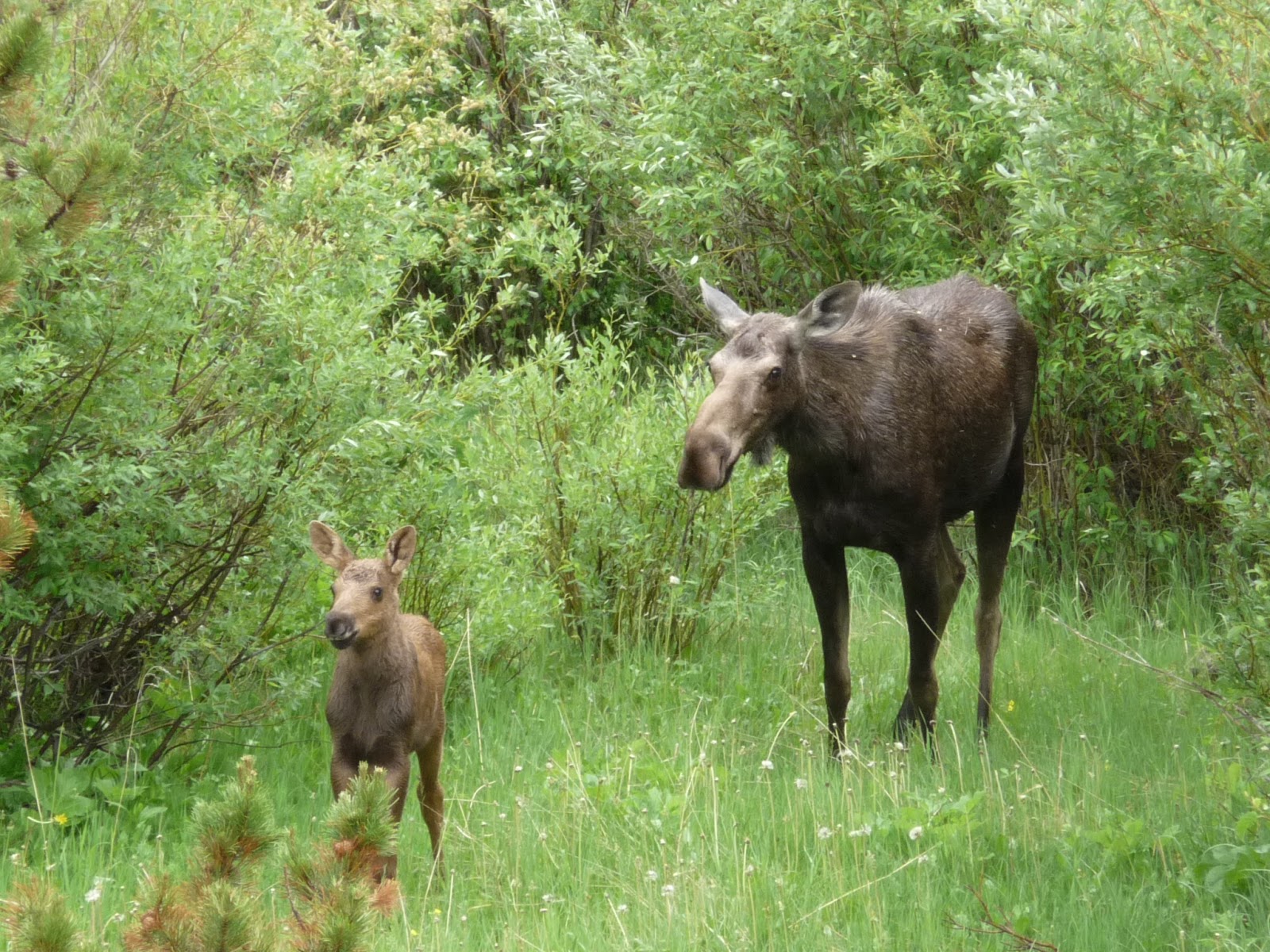
It was definitely a hike with great views and worth all the efforts to get up there. A few of us felt exhausted from the hike, especially the hike in the rain so we decided to skip the after hike lunch and headed back home. When we turned from 119  to 72, we saw a moose and her baby! What a great reward to our long day!
Moose Mom & baby

Monday, June 24, 2013

Hoosier Pass & Continental Divide

Hoosier Pass is the perfect trail for people who would like to escape from the heat in the city by hiking above the tree line but have hard time to keep the breath while climbing for a good elevation gain.  The hike is easy and less than 4 miles round trip from the trailhead to Crystal Lake with about 700 elevation gain. But what you get is the spectacular view of three 14er: Mt Bross, Mt Lincoln and Quandary in addition to the stunning lake view.

To get there, Google maps will lead you to I-70 west towards Frisco/Breckenridge. Exit on 203 then follow CO-9 south to travel for about 10 miles. The parking lot is on the left with a big sign. We were afraid of the possible traffic jam and the blast on I-70 so we took an alternative – US285, which also connects to CO-9. The travel time is about the same for these two routes on the map and the view along US285 is fabulous.

There is a big map on the parking lot but no restroom. The trail starts from elevation 11,539 feet (I am using the number from the sign but I have seen 11,541 on many other resources – must be something more accurate).

This is what I found on summitcountyexplorer.com

"
Hoosier Pass rises to an elevation of 11,541 feet. It's a high mountain pass in the Rocky Mountains of central Colorado, situated on the continental divide at the northern tip of Mosquito Range in a space between Mount Democrat in the west and Hoosier Ridge in the east.
"

It didn’t take us long to get to Crystal Lake although there were a few barriers along the trail. We continued to hike up to the hill for a great overlook of the lake then got to the bottom of North Star Mountain to check out one of the mining ruins. The additional hike took us to above 12,000 feet and to pass the 2-mile mark.  

On the way back, instead of following the way we came, a couple in the group who are very familiar with the area took us to the other trail that runs over the ridge. After passing the Crystal Lake trail, we made a right to get on this steep trail. It is an uphill trail all the way to the ridge. This was the only challenge we had for the entire hike but it was a great exercise and gave us a chance for an even better view. The route we did was probably between 5-6 miles round trip and took us about three and a half hours. Even though it is considered as an easy hike, wearing a pair of comfy waterproof hiking boots and proper socks are highly recommended.  

After the hike, we went to South Park Saloon for a late lunch. The food was OK. There was a kick ass BBQ competition held in Alma, which made this tiny town pretty crowded. 

Now let the pictures tell the story!


The mountain view along 285
Huge sign in front of parking lot
Our hiking route


Water on the trail


Mining ruin

The uphill trail


Ice covers the entire trail - either go downhill to avoid the ice or step throug the ice carefully


Ice on the trail

Another water covered spot