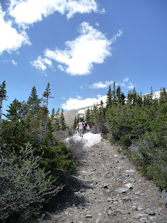
Hoosier Pass is the perfect trail for people who would like to
escape from the heat in the city by hiking above the tree line but have hard
time to keep the breath while climbing for a good elevation gain. The hike is easy and less than 4 miles round
trip from the trailhead to Crystal Lake with about 700 elevation gain. But what
you get is the spectacular view of three 14er: Mt Bross, Mt Lincoln and
Quandary in addition to the stunning lake view.
To get there, Google maps will lead you to
I-70 west towards Frisco/Breckenridge. Exit on 203 then follow CO-9 south to travel
for about 10 miles. The parking lot is on the left with a big sign. We were
afraid of the possible traffic jam and the blast on I-70 so we took an alternative –
US285, which also connects to CO-9. The travel time is about the same for these
two routes on the map and the view along US285 is fabulous.
There is a big map on the parking lot but
no restroom. The trail starts from elevation 11,539 feet (I am using the number
from the sign but I have seen 11,541 on many other resources – must be
something more accurate).
This is what I found on summitcountyexplorer.com
"
Hoosier
Pass rises to an elevation of 11,541 feet. It's a high mountain pass in the
Rocky Mountains of central Colorado, situated on the continental divide at the
northern tip of Mosquito Range in a space between Mount Democrat in the west
and Hoosier Ridge in the east.
"
It didn’t take us long to get to Crystal Lake although there were
a few barriers along the trail. We continued to hike up to the hill for a great
overlook of the lake then got to the bottom of North Star Mountain to check out
one of the mining ruins. The additional hike took us to above 12,000 feet and to
pass the 2-mile mark.
On the way back, instead of following the way we came, a couple in
the group who are very familiar with the area took us to the other trail that
runs over the ridge. After passing the Crystal Lake trail, we made a right to
get on this steep trail. It is an uphill trail all the way to the ridge. This
was the only challenge we had for the entire hike but it was a great exercise
and gave us a chance for an even better view. The route we did was probably
between 5-6 miles round trip and took us about three and a half hours. Even though it is considered as an easy hike, wearing a pair of comfy waterproof hiking boots and proper socks are highly recommended.
Now let the pictures tell the story!
 |
| The mountain view along 285 |
 |
| Huge sign in front of parking lot |
 |
| Our hiking route |
 |
| Water on the trail |
 |
| Mining ruin |
 |
| The uphill trail |
 |
| Ice covers the entire trail - either go downhill to avoid the ice or step throug the ice carefully |
 |
| Ice on the trail |
 |
| Another water covered spot |


No comments:
Post a Comment